Wednesday 30 May 2018

The Fleur-De-Lys and The Blocked Door

After a week off I'd like to say I returned to work with a feeling of renewed vigour and enthusiasm. But being a normal(ish) person of course I didn't. I felt half sharp and somewhat begrudging. A slightly extended lunchtime walk might help, I thought. Additional motivation was provided by the office 'walking challenge' currently happening, based around increasing one's step count over about a month. Anything that gets people walking ought to be suported, I thought, particularly if it facilitates additional perambulatory activity during the working week. I had my pedometer on and went out into the murky greyness.

Still feeling a bit off kilter following the transition from week off to back on the work treadmill, I wasn't really in tune and didn't really notice anything for most of the walk. My route ended up being a sort of loop, round some residential streets that eventually lead me to Central Park. Nothing stood out.

I had lunch in the park. I had thought of getting a coffee in the cafe, but it was closed. Fully caged up. This seemed particularly odd given that it is half term.

I ended up walking back to work along Eastfield Road and it was only towards it's end that I became more 're-tuned'. This happened when I noticed a door. Or rather an ex-door, on the corner of Monument Street. More precisely, first I noticed the Fleur-De-Lys motif above. Then underneath, the door featuring blue tiling around the edge and a sort of porch above it. It was a few seconds before I noticed the door was bricked up, but only about three quarters of the way up. The remaining section being what looked like the remains of the door with it's window boarded up. Sort of reminiscent of the way many new buildings have the top section made out of or clad in wood. And equally inexplicable as to why this should be the case.


At first glance the door resembled that of a police station, then made me think it might have been the entrance to some sort of club.  A British Legion or Conservative club, that sort of thing. Or possibly a dead pub, The Fleur De Lys is a widespread pub moniker after all. I wondered if it could have been the headquarters of some sort of defunct fraternal society. The Fleur De Lys, although mostly associated with France, is, in it's silver on blue incarnation, the central feature of the coat of arms of the Baron of Digby. Whatever the explanation for the building and it's symbolism, it remains hidden behind the bricked up door and the plethora of Google hits for estate agents that come up on a search for 'Fleur Dear Lys, Monument Street, Peterborough'. I could only be bothered to go three pages in before I gave up. The other mystery, apart from  the partial bricking up, being the identity and motives of SG and rBs.


Wednesday 23 May 2018

Transdiffusion in West Runton: Y Stations, Black Shuck and Punk Rock

A trip away to the Norfolk coast. We stayed in an Air BnB sourced bungalow, situated on an estate of almost identical bungalows. The Royal Wedding was on the day we arrived.  Large flagpoles in two of the neighbouring gardens flew the Union Jack. Other houses featured bunting and various other royal parephenalia. We saw no one one the first day on the estate, a trend that pretty much continued. If it wasn't for the pristinely maintained gardens it would have been easy to mistake the area for an abandoned holiday park. Once we had been there longer, the atmosphere felt more like an extensive retirement village, which it sort of was.  Not quite a real place.  Portmerion without the interesting buildings and people. More Neighborhood Watch than sinister surveillance, mind control and large white 'rover' balloons. But only a bit more.

On the second day we walked. Leaving the 'village'. The flag on one of the poles had been taken down, the other looked withered in the eeerie light of the morning sun, obsured in the haze of a sea fret, looking not unlike a 'rover'. But we escaped to Sheringham without incident.


After walking into Sheringham, we climbed the Beeston Bump. I say climbed. The footpath has been much improved since my last visit. It seemed a much more gentle slope that I remembered. The Bump is gradually eroding, but I think my perception of the changed incline was more to do with the erosion of my memory. Someone I was at sixth form with did a geology project on the bump and told me it was a drumlin. I couldn't find any reference to this elsewhere, but it is certainly the result of glacial activity. There was a second bump nearby many moons ago, which has been eroded away entirely. 


The Bump is said to have been (be?) the lair of Black Shuck, a large ghostly black folkloric dog that is supposed to roam the coastline and countryside of East Anglia. An encounter with the beast a portent of death within the year. In some accounts it has one eye, like the Cyclops of Greek myth. Black Shuck is associated with the black hound of Odin, the origin of the legend possibly being brought to East Anglia by the Vikings. Arthur Conan Doyle is said (at least by the tourist info sign on the Bump) to have been inspired by the legend to write Hound of The Baskervilles after staying in the area. But Wikipedia claims that the inspiration was the Devonian legend of Richard Cabbell, of Buckfastleigh. Variations of Black Dog folklore exist throughout the UK, and tales of Black Shuck also vary.  Sometimes he/she is not a bringer of doom but a companion.

There were several people of advancing years 'climbing' the mound, possibly inhabitants of the 'village'. They were a recurring feature as we made our way along the coast. Many had dogs as companions but I didn't see any large one-eyed black ones.

At the top of the bump is a concrete patch, the remains of a second world war Y station. The East Anglian coast had several Y stations, receiving and sending on radio signals to 'Station X' at Beltchley Park. The the image shown on Wikipedia (below) shows a bizarre octagonal based building looking like a combination of a bomb shelter and a windmill. It looks like it comes with an accompanying soundtrack of barely audiable shortwave radio.


Near to where the building used to stand is a trig point. I'm not sure if trig points always have a depression near each corner. Maybe this is a special edition including coffee cup holders. More importantly (in my mind alone probably) is that one corner of the trig point lines up with the West Runton TV mast which can be seen in the trees in the distance. Just not very well on the photo below, but it's somewhere beyond the head of the woman sitting with her back to the trig point. The TV tower is a 'relative' of the infamous Sandy Heath Transmitter, who's image seemed to feature on TV when I was a child almost as often as the Testcard. Usually in the morning during the mysterious 'Trade Test Transmissions' when it would be accompanied by some 'muzak'.


After crossing the bump, we carried on along the clifftop. Reaching Beeston Holiday Park we were confronted by the first of a series of signs telling us the rules. Activity at the fishing pond is governed by a long list of them.


The Laburnum Caravan Park has two notices, the newer one more prescriptive and keen to remind us that we are entering private property, as if we should feel privileged and think ourselves lucky for being able to do so. I preferred the old sign which was a bit more battered and friendly.


Laburnum Caravan Park, which is in West Runton, is where I used to be brought as a kid on our 'second holiday'. Our first usually being in Great Yarmouth but not always. My Dad's boss had a caravan here which he let us rent cheap for a week every August. West Runton and the caravan park in particular, are engrained in my psyche as a result.

We had a wander round the area at the top of the caravan park. The caravan I used to stay in, like all the others, had been replaced with much posher and more permenent looking models. They probably have running water and electricity now. Before there were strange smelling calor gas powered lights and cookers which had to be lit using matches, as well as standpipes dotted around the camp to collect water from.

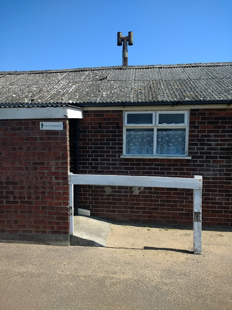
Meanwhile the cluster of single storey brown amenity buildings were still there but they showed no sign of significant renovation. Indeed, the former gentleman's lavatory was boarded up and apparently disused. Here, people used to use the sinks to wash their faces and clean their teeth in the morning, before carrying their washbags over to the shower block to finish their ablutions.  The toilets provided my first encounter with a condom machine which my dad told me contained bubblegum. I was somewhat miffed that he wouldnt give me 10p to get some and only realised a few years later that the machine really vended 'rubber johnnies', not 'Hubba-bubba'.

We were lucky, I suppose, to be in a caravan located quite near to the block. Particularly for my Dad after a he'd had a few pints Red Barrel, a 70s keg beer which made up for its lack of flavour by having powerful laxative qualities. He wasn't the only one in the 'stalls' suffering its effects at 3 in the morning apparently. The establishment providing the offending beverage, the West Runton Social Club, was just down the other end of the road that led from the caravan site and emerged into West Runton, a very small village.  We didn't venture in that direction on this occasion, but the club is still there and welcomes non-members. As well as Red Barrel it used to offer Bingo, pool and Galaxians and the opportunity for the temporary residents of Laburnum Caravan Park to mix with the locals.


The migration of the gents to the old shower block was a bit disorientating. I felt like I was in a different version of the place I recalled from the past. We saw nobody and there was a conspicuous absence of posters advertising variety shows at Cromer Pavilion Theatre that I remembered always being displayed on the side of the shower block. These were oddly surreal, always in a mono dayglow pink, green, orange or yellow with black and white faces of the 'stars'.  The bigger the 'star', the higher up the bill and the position on the poster, and the bigger the  face. The faces were always neckless, floating as if they were apparitions in a parallel provincial showbiz dimension, smiling and slightly unsettling. Little and Large, Danny La Rue, Jim Davidson, Bernies Winters and Clifton (with ostrich) and Cannon and Ball among a rotating cast of grinning 'entertainers'. Seaside piers are still a stronghold for this type of 70s-esque entertainment, which has been pushed out or retreated to the margins of the coast, rarely seen inland or on telly anymore.


I was only ever subjected to one 'seaside special' style show which stared The Krankies and Russ Abbot , as well as some dancing girls. I knew the Krankies from the TV programme 'Crackerjack' and was still young enough to have been convinced that Jimmy Kranky was a real boy. This illusion was shattered when Jeanette Kranky did an encore and sang a song dressed as herself. Things got even worse when Russ Abbot came on with his backing band 'the Black Abbots'. My dad seemed to find whatever they were doing hilarious. I didn't and was bored for what seemed like a very long time until they went off. Having witnessed this, it's easy to see why alternative comedy needed to happen.

At the same time as young children were being made to  suffer the tedium of Russ Abbot and his ilk by their parents, older kids were escaping theirs and going to see punk bands at the West Runton Pavilion. A counterpoint to its Cromer namesake, the West Runton Pavilion played host to bands like The Sex Pistols, The Damned and Siouxsie and The Banshees and is now the stuff of legend. The remit was wider than just punk, but firmly in the less mainstream arena. At the time I was unaware of all this. My only recollection of being in the building is at a children's roller disco. I dimly recall somebody saying Blue Oyster Cult were playing The Pavilion one night when the area seemed to have been swamped by lots of 'headbangers' in leather jackets and denim cut offs. This was the only time I remember a gig there being mentioned while I was on holiday and I wasn't sure what they were on about, being about 9. But Blue Oyster cult  did indeed play there, for some reason under a different name.

Years later I had a tape of the Dead Kennedeys 'Live at Cromer'. This almost certainly was at the West Runton Pavillion, not in Cromer just up the road. The internet confirms the venue did indeed exist and West Runton, a village of probably less than 1000 people and few amenities was the epicentre of alternative music in Norfolk in the late 70s and early 80s. Something that feels a bit like it was made up or dreamt. By the time I was old enough to have appreciated it, it had gone and I had stopped going on holiday with my parents.


Any advertising had shifted to the side of the still functioning shop, but no day-glow posters were to be seen. I will forever associate this shop with tetra-pack milk cartons, which my parents used to buy most days when we stayed there. The opening of the cartons only marginally less frustrating and annoying than trying to do a Rubik's cube, and often a lot more messy.

The other significant locus in the caravan park for me was the rec. This used to be at the bottom end of the caravan park, consisting of a large green area at the 'end of the caravans' which contained a tennis court and at one end the usual collection of rec apparatus: a slide, a see-saw and swings. Slightly more unusual and a bit more dangerous was a swingboat which squeeked loudly despite the clumps of grease administered to its joins by the joyless caravan park caretaker. There was also a horse, which we discovered still existed along with the see-saw on a relocated and reduced rec not far from the toilet blocks, part of another large green area that was the territory of Peter Powell Kites and balsa-wood gliders.

I have semi-vivid memories of looking beyond the caravan park from the rec,  inland towards a distant looking forest in the hills. Growing out from the trees was a l ariel mast, which seemed to belong to a distant and unreachable place. This fascinated me at the time.  Maybe because it looked similar to the aforementioned Sandy Heath Transmitter, who's static image had undoubtedly been embedded in my subconscious during the trade test transmissions I'd seen while having breakfast in my pre-school years. During this walk my main 'objective' so much as there was one, was to reach the base of the West Runton Transmitter Mast, spurred on by the earlier sighting from Beeston Bump. My partner was less enthused by this endevour, but humoured me.


The Rec Horse looked like it had been reconditioned, less so the see-saw. These sat among more contemporary apparatus and on a surface of rubbery material apparently manufactured by 'Wicksteed', the name of a sort of amusement park near Kettering which I have vague memories of visiting during the same era that I originally played on the horse. Prior to their migration and the Wicksteed floor intervention, the horse and see-saw had been fixed on unforgiving concrete, often resulting in minor injuries. One boy, who my mum described 'having St Vitus Dance' got over-excited on the see-saw and fell of, breaking his nose.


The caravan pit, round the back of the amenity block, looked abandoned. This was the domain of the miserable caretaker, who I remember being chased away by with some other kids when we climbed in to see what we could find. We had a sort of gang, which being nine year old kids was a sort of poor man's Red Hand Gang. Instead of James Bond the Third and chopper bikes we had one fish-handled penknife between us. But the caretaker acted as though we were the most dangerous menace Laburnum had ever faced.


I dragged myself back to the present and we made our way out of Laburnum Caravan park and headed towards the beach. Not wanting to end up like the stick man on this notice, be considered fools or wanting a ride in a helicopter, we followed the more shallow incline of the concrete slope further up.


Apart from a cafe/toilet block, there was another structure, apparently randomly placed, a sort of shelter with a community noticeboard inside. One poster advertised 'geology walks' but these had been and gone on the day we arrived.


Onto the beach, the cliffs have some bizarre features . Here the rock has been blackened, as if scorched by a localised fire caused by some sinister force or being.


Possibly this was explained by the nearby footprints below. Had the hellhound Black Shuck passed across the rocks before making its way up the beach in the direction of Cromer?


Further along a rusty pipe served as an outlet from somewhere deep within the cliffs. Maybe a hangover from the days when sewage was pumped into the sea, while from the other direction oil spills washed up onto the beach frequently.


Looking along the beach towards Cromer, there were few if any people. The scene reminded me of the beach in the climax to the film Planet of The Apes. It could have been an another planet. Or this one in a more desolate future.


A  sunken pillbox added to the brief feeling that we could have been propelled into the future, after some sort of cataclysm. The unstable cliffs are, I suppose, in a sort of slow motion cataclysm of their own, undergoing a destruction imperceptible when measured in everyday time. The pillbox was up on the cliffs in the second world war but the shifts since then have rendered it fallen and sunken into its current position. In geological terms, a timeframe so small as to be microscopic. I wondered how many more years it would take the cliffs to retreat as far as West Runton Social Club.


We drifted along the beach into Cromer. The modernist looking almost nautical look out building was put there for holiday makers, not the army. But its still standing. Typical architecture of the British seaside town, Cromer has several of these sorts of shelters dotted along the sea front where you can just sit, with sufficient shelter from the elements. Much better than the common park bench found inland.


The nautical theme continued with these impressive two story beach huts.


The path elevated us upwards towards the town. The list of names below probably a gang of kids on holiday. One apparently called BladE. I wondered if fish-penknives were still a 'thing'.


A stone memorial bore the simple but ambiguous legend A D 1900. Maybe this marked the beginning of Cromer as a seaside resort. Maybe something else. It looked like it pre-dated what was around it and it appeared that it's surroundings had been arranged so it could be left in situe as if it was something to be revered. The attached green sticker, depicting a water tap above what looked like a violent sea, an ambiguous symbol, possibly linked to the purpose of the stone.


We rested for fish and chips and sat on one of the seatng areas between the road and the sea, hovering between the beach and the town on a concrete platform. We (or more likely our chips) were observed by a crow. The name Cromer is likely a corruption of 'Crowmere' meaning Crow's Lake. I don't know of any lakes in Cromer, other than the boating lake across the road from where we were sat. Maybe it serves as a current crow meeting point. The bird lurked patiently, but didn't get any of our chips. We needed the energy for the next stage of the walk, out of town and into the forest to loop back to Sheringham via the West Runton Transmitter Mast.


We passed through the town and 'out the back way'. On the fringes of the town we passed this curious establishment selling (presumably)  'Ales, Gas N' Lager'.  It looked of a certain vintage and I wondered if it had been the supplier of Double Diamond, Harp Lager and the dreaded Red Barrel to local pubs and social clubs a few decades ago. The reference to 'gas' presumably referring to the sort used to dispense beer rather than calor gas or North Sea gas. I  didnt stop to investigate, though, so I can't guaratee it. The window confirmed that it was an outlet for the Poppyland Brewery, which does a more contemporary beer range. The area around Cromer was/is known as Poppyland due to the prevalence of wild poppies. We must have come at the wrong time for them, I can't recall noticing any.


A boarded up mock Tudor building, looking not unlike a 'Tolly Folly', had most recently been used as a bar and lounge called 'Bouncers'. A name with dubious connotations whichever of its meanings are applied. Apart from, maybe, the unlikely scenario that it was named after the dog from Neighbours. I imagined this was an establishment sufficiently far enough away from the main tourist drag that the police turned a blind eye to local debauchery and at least knew where it was happening, until things got so bad they had no choice but to have it shut down. On the other hand it could have been too far for anyone to be bothered to walk or for many people to know about it, and just another marginal business finished off by the austere times we live in.


Another building with metal boarded windows was the flint chapel in the graveyard further along.  The original windows, as well as the land the graveyard occupies, were donated in the late 1800s by  Benjamin Bond Cabbell, who was a British Conservative politician and philanthropist. Not two things that can easily be imagined going together these days. He had a country house in Cromer, which at one time could be reached by a path from the cemetery. That and the windows he donated have disappeared. It appears the council has been trying to raise the funds to renovate the chapel, and presumably replace the windows, since at least 2008. Conan Doyle had dined as a guest at the Country House where Cabell furnished him with the tale of his Devonian ancestor and the hellhound, thus becoming another candidate as the person responsible for bringing the legend of Black Shuck to the area. The information provided on Beeston Bump didn't mention this, and shows the 'tourist information' provided by the heritage industry is sometimes presented within a certain margin of poetic licence.


Having left the outskirts of Cromer we travelled along a sandy path, passing under a striking orangy-brown railway bridge supporting the line between Sheringham and Norwich. It was the last piece of civilisation we would see for a while, and acted as a portal into the woody heathland that made up the next phase of the walk.


The path through the woods went on for sometime, often narrow and uphill. We saw few people and on several occasions were not sure that we were going the right way. We took a diversion at one point through a National Trust area of heathland, following the official paths which resulted in a dead end. Eventually we emerged onto a wide path/road where the land reached a plateau.


Signs of civilization began to reappear. Partially hidden in a hedge was an electricity facility featuring the familiar danger of death symbol and a helpline phone number for those facing it in the vicinity of 'Runton Tea Gardens G1844 41340'. Below this, the message appeared to be translated into an alien moss green scrawl.


Soon we reached the site known as the old Roman Camp. Whether there ever was a Roman Camp here is a moot point. It's been said it never existed, but is a tale used to draw tourists to the area. On the other hand, evidence of Saxon industry has been found here but perhaps the tourist authorities don't think that has the same ring to it.  The site is known as Beacon Hill and is part of the Cromer Ridge, which we had been walking along. The ridge is made up of old glacial terminal moraines which marked the reach of the ice sheets during the last ice ages.


Beacon Hill is marked by a lichen infested flint based box. It has a roof and a metal panel with a small slit and a keyhole. What was kept locked inside I'm not sure. It may have been an elaborate donation box for the National Trust. But it looked like it had been unused for sometime, and seemed a curious and random structure.


Behind it was a post, marking the highest point on the ridge and in Norfolk, a county usually thought of as being flat and featureless. When I had first seen the post from a distance I thought it was the TV mast. I realised I must have missed the mast, somehow bypassing it in the woods. This seemed impossible given it was the most significant landmark in the area. But I had.

A faded map on Beacon Hill showed the location of the transmitter, not far away. My partner stayed to enjoy the view on the hill, while I re-entered the woods.

It only took a few minutes to locate the base of the transmitter which I approached through the deserted and quiet woods. At the base, surrounded by a fence festooned with a plethora of notices, warnings and imcomprehensible information. An unassuming brown box building sat at the base of the mast, along with a handful of electricity/telecoms boxes of various shapes and sizes. There were no people and a sort of sterile and otherworldly peace permeated the base.


The tower was impressive, in the form of a giant mutant pylon with various dishes attached to its sides and a white post pointing up from it's peak. Apart from the liminal nature of transmitter masts and their sinister hauntological aspect connected to 70s trade test transmissions, they are also the source of the both mundane and bizarre world of Regional television and radio. The white post at the top of the structure seemed to conjure up images of the Anglia Knight and Graham Bell. Meanwhile thetmysterious sounding Yagi Ariel near the top of the tower had been added to mark the 25th anniversary of Radio Norfolk, strengthening the FM signal and allowing the voices of real life Alan Partridge types to permeate the airwaves like never before.


The West Runton transmitter broadcasts Freeview TV and radio to about 11,000 people in Norfolk. It's one of a series of lesser transmitters in East Anglia, in areas too East to be served by the bigger Sandy Heath Transmitter.  The 'partition' of the Anglia TV region into East and West in about 1990, to ensure people get news from 'your part of the region', meant where I lived there was an instant news blackout from the East of the Region, while we received news of the West, mainly dominated by stores from Corby, Northampton and Milton Keynes. Places I wasn't previously even aware were part of the Eastern region and which seemed more remote than, say, Ipswich or Norwich. For some years before I got round to visit Norwich and Ipswich they were frozen in time in my mind based on pre-1990 visits and images lodged in my head from About Anglia. Corby and Northampton, meanwhile, still  belong in the East Midlands in my brain, the former a Glaswegian collony of flat roofed pubs and abandoned steel works, the later the base of Carlsberg and Alan Moore. Milton Keynes belongs in a time and place of it's own. The TV region seems out of kilter with East Anglia as it exists in my mind, as if the map had been slipped to one side during a clumsy weather forecast and never put back.

The tower was smaller than I'd imagined all those years ago from the rec, but it was still a bizarre and slightly unsettling site.

We headed away from Beacon Hill, past a horse sanctuary and through some heathland towards the village of Beeston Regis. Somewhere around here we were afforded a view of the Beeston Bump looming up in the distance.


Having descended onto the road to Beeston Regis, we had evidently arrived via a track unsuitable for motor vehicles. Near the bottom this was made clear along with the more ambiguous warning 'No Sat Nav'. I wondered what the penalty was for navigating using this new-fangled technology.


Beeston Regis was a place eerily quiet and without signs of life. It was like an older version of the 'village' we were staying in and I guessed predominantly inhabited by the retired. The name Regis has something to do with Royal patronage. The place felt like it would probably come to.life in the event of a royal wedding or birth, but otherwise stay dormant.


Beyond the village is Beeston Regis Common, a marshy nature reserve. This offered a Lovecraftian path back to our 'village'. At this point my phone battery died and my recollection vague, my legs and cognitive abilities having reached their limits. But we made it back to our bungalow and the 'village'.

Wednesday 16 May 2018

Danger of Death 1925.

Last Thursday I managed a brief lunchtime wander in Peterborough. I had my lunch in Central Park, in the seclusion of the Sensory Garden. I had considered sitting outside the cafe, where I'd purchased coffee. But the tables had all been taken by a large group of octogenarian looking people clad in what I presumed were army uniforms. They looked like elderly members of the Boys Brigade.

On leaving the park, I passed three more elderly people. A man and a women both wore what looked like mayoral chains of office. A third man wearing a suit, bowler hat and carrying an umbrella appeared to be their assistant. I assumed they were about to convene with the ''boys brigade" for some sort of ceremony or ritual.

Across the street from the park I headed along a fairly pleasant residential street. Among the houses was a bizarre building housing (I assume) electricity. The top half looked like it may have been residential at some point, while the bottom was basicallyb large windowless cupboard with a yellow 'danger of death' sign warning against any attempt at entry. The building, date stamped 1925, and resembled a giant mock-Tudor tardis. A brief (but admittedly less than thorough) internet search revealed nothing about it. The buildings mysterious quality remains intact.


A few minutes later I was on Eastfield Road. A sun-shrivelled man, probably in his 50s, spoke to me as I passed in an indeterminate accent. I couldn't understand what he said but he was seemingly offering me the chance to purchase the items in the plastic bag he carried. I didn't break my stride so didn't properly see what the bag contained. It appeared to be blue cartons, possibly cheap unlabelled cigarettes, or maybe knock off prescription pills or Viagra.

5 minutes later I was back at work.


Tuesday 15 May 2018

Telegraphs, Gas and Anarchist Hobby Horses in Norwich

Changing trains at Norwich, the plan had been to stop off and have something to eat at the Coach and Horses, and get a later train back. I walked down Thorpe Road but before I reached the pub noticed a footpath signposted as leading to Rosary Road. Beside being one of those paths that draws you in, Rosary Road rang vague bells. I took the diversion.

The path led behind some houses, on.hiher ground. Soon it forked. I took the left turn, shortly to emerge onto Rosary Road. The place was familiar and a few seconds later I saw the pub, The Rosary Tavern. I had been here before, some years ago following an afternoon at Norwich Beer Festival. I had stubled across the pub on a convulted walk back to the station by happy accident. It was mentioned in the beer festival programme as being 5 minutes from the station (I hadn't seen the ad until I was actually in the pub). It was only 5 minutes using the path I had just taken. But at the time went a different way, only having a vague notion of the direction of the station. It had taken 30 minutes.

Rosary Tavern, Norwich, Rosary Appartments, Psychogeography

The building was still there but on closer inspection it was no longer a pub.  A plaque on the wall showed it had closed in 2009, having been a pub for over a century.  The pub sign simply reads '95'. Above the windows, where the name of the pub had one been it now says, in wording just about visible, 'Rosary Appartments'. Serviced apartments I think. In the old days the pub had been part of a planned estate housing employees of the gas works. I was sorry to see the pub gone.

I made my way downhill back towards Thorpe Road, past the 60s low rise flats next to the pub and a semi-brutalist car park/office block opposite. Eventually I came to a left turn and headed to The Fat Cat and Canary for a swift half and a pork pie. It was sunny and the front yard was occupied by builders who had knocked off for the day and their vans.

Suitably refreshed, I carried on along the road for a bit before turning left, having decided to try and do a circular walk back to the station. I found myself on 'Telegraph Lane East'. The road quickly became a steep (for East Anglia) incline and a tree lined road with some largish houses. A bit reminiscent of Hampstead, but not quite as posh.  Late I discovered the area is known as 'Thorpe Hamlet'. Parts of it had a feel of a village within a town, a sort of separate state resisting the encroachment of its surroundings. Keeping the riff raff out.


I noticed a number of blue signs that I first thought pointed to cycleways. Coming from Cambridge, why would I think they were anything else? But they were signs for pedestrian routes, which is something you don't see everyday and was heartening. And useful for someone not really knowing where he was going. Up to a point anyway as most of the nomenclature was meaningless to me.

I passed a primary school, and notice one lone parent with a pushchair up ahead. No one else around. I crossed the road and saw up ahead what looked like a water tower. Closer inspection confirmed this. A water tower with an added bonus of a TV/radio or maybe mobile mast on top of it. It seemed unusual to encounter a water tower within a city. Victorian proto-brutalism at its best!

Water Tower, Norwich, Psychogeography, Telegraph Lane

Further along the road seemed narrower and more like a lane. The woman with the child in a pushchair I'd seen earlier had paused ahead. When I passed she stopped me and asked if I lived round there. There was a starling apparently in distress, and she didn't know what to do. I apologized and said I wasnt local and didn't know the drill for injured birds except to advise her call the RSPCA. She thanked me but looked uncertain. I thought the encounter a bit odd. The woman was middle class and confident sounding but had no idea about what to do about her concern for the bird. I left the scene, feeling a bit guilty for not offering to call the RSPB, as well as puzzled as to why the woman hadn't thought of doing this herself. I was wearing a suit so maybe I was projecting some sort of air of importance or authority that I really don't possess. The encounter showed how deceptive appearances and first impressions can be. Anyone can buy a suit from M&S for less than a ton, and anyone can cultivate a middle class accent should they so wish (I never bothered). Both part of 'spectacle' and facade.


Shortly after this the road became 'Telegraph Lane West'. The lane narrowed and started its decline downhill. I passed a splendidly decrepit sign for a pub, The William IV'. I couldn't actually make out where the entrance was but seeing the sign for sports screens I  didn' investigate further.

Telegraph Lane West continued, tree lined and narrow.

Norwich, Telegraph Lane West, Psychogeography, Thorpe Hamet

I passed a metal gate, festooned with indicipherable graffiti tags. Frustratingly I couldn't make out what lay beyond it.


A little way further, near the end of the road I encountered a magnificent gas holder. A water tower and a gas holder on the same stretch of road, in a city, not in the 'edgelands'. I felt almost blessed.

Norwich, Gas Holder, Thorpe Hamlet, Psychogeography

When I got to the end of the road it was apparent that at some point it had changed from Telegraph Lane West to Gas Road. Stands to reason I suppose.

At the bottom on the corner was the Lollards Pit pub. Coincidentally I had seen the pub on TV a few weeks ago in a programme presented by Dr Alice Roberts about Tudor Norwich.  The pub is so named since the Lollards, seen as heritics, were killed and buried on the site which at the time was outside the city walls. The site was shunned for a period but these days the pub features most of the hallmarks of a thriving decent boozer with a heritage angle. Apparently there is a well in the garden (I didn't have time to look) and it had a fairly convincing old world feel, despite Jimmy Somerville pleading not to be left this way from the TV on the wall.


A bizarre flyer, featuring a ghostly looking hobby horse caught my eye. Robeet Kett led a rebellion in Norwich following the enclosures and resulting hardship caused the to people of Norfolk in the 1500s. He was hung soon after. Ketts horse, and the morris/molly troup accompanying it, appear to be harnessing the rebellious spirit of this part of Norwich which goes back through the layers of it's history. I hadn't detected much of a spirit of rebellion in Thorpe Hamlet but it was only Wednesday afternoon.

'No one man is the horse. We are the Kett's Horse Society. We are the Guild of the Glad Man Ribnoners. We are the resurrected skeleton army of Stump Cross. We are the stump cross Ex-Residents Club. We are the Now or Never! drinking club'.

Over the road, I found myself on the officially sanctioned Riverside Walk. A sudden shift away from the arcane memories contained in the Lollards Pit, and the odd combination of edgelands and Hampstead that was Thorpe Hamlet. Soon after the path forced me through the beer garden of The Compleat Angler pub and across the road to the Station and home.


Friday 11 May 2018

Rural wandering in South Cambs X 2

Peterborough walks have been on a hiatus lately due to business at work  and working away. Then the bank holiday, when I spent a couple of afternoons walking with my partner around some of the villages just south of Cambridge.

My partner is much more rurally orientated than me, which means I occasionally venture out to a place I previously wouldn't have bothered with much before: the countryside . Left to my own devices I'd have been unlikely to go out into the sticks very much. In the past I considered the countryside a bit boring, conservative, remote, difficult to get to (and more importantly from) and lacking in amenities. More recently, I've learned to drive so going to these places is more possible and forces me to practice. Going anywhere by car is still my least preferred  mode of travel, but does have its uses on these occasions. Before my attitude had been if somewhere couldn't easily be reached by foot, bicycle or public transport (preferably train, not bus) then it probably wasn't worth going to. My view has shifted in recent years, and i'm nearly as happy going for a rural wander as an urban one. I don't know if this is because of gentle coersion by my partner, learning to drive, or just getting older and appreciating different things.

Walk 1: Eversden Woods and environs.

The first walk involved parking up in the village of Great Eversden. My memories of the village itself are already a bit vague. Nothing remarkable, bigish houses and big gardens indicating fairly well off residents, no pub (apart from one now operating as an Indian Restaurant), no shops or cafes. There was a church (more of this later). We parked near it and headed off down a footpath. The objective of the walk was to go to Eversden Wood where we could catch the last bloom of bluebells. We thought it would be less busy than the other bluebell woods in the area which were more well known being managed and advertised by people like the Wildlife Trust. The irony of going out to the countryside to get some peace and tranquility away from town, only to be thrust among a mob of families and their dogs was something we wanted to avoid.

Before reaching the woods we stopped for a rest on a ridge, overlooking a farm, the village and towards Cambridge. The behemoth of Addenbrokes Hospital could easily be seen in the distance, as could Eddington and the wind farm near Fleam Dyke near the village of Fulbourn. There was nobody about on the ridge. It was peacful yet strangely surreal. It's not often you get up high in Cambridge (I'm talking very relative, it wasn't Ben Nevis). It was a bright and sunny day and lhe light was reminiscent of that on 70s TV programmes I remembered seeing about the Countryside as a child. At that time it seemed another world, one I wasn't particularly interested in. One where a patronising man told you to follow the country code and notices told you to keep out of fields. The light had a strange quality in these programmes which seemed to be slightly off kilter with real life. Maybe it's the type of film they used. But it seemed to mainfest itself on the ridge.

We got to the wood. Suddenly in the shade, out of the sun which was getting a bit much for me being a pasty faced individual with little tolerance for it. The bluebells were competing with a profusion of other plants and brambles. We saw nobody else as we progressed into the wood along a path that became increasingly quagmire like the further we went. A prolonged wet spell had left it's mark.

My choice of footwear was a bit ill advised for this sort of thing. Roamers 'Jason' suede slip on desert boots are ideal for walking in an urban environment (or anywhere dry and not too lumpy really). But they are neither water or slip proof. Just as things were starting to get awkward I found a large stick which I could use as a steadier and to gage the depth of puddles. I felt like a character in one of those terrible dungeons and dragons games, who finds a significant object that will assist in the quest. In this case to get to the other side of the wood without slipping into water, nettles or brambles. The staff of stability! I briefly fancied myself as a sort of Merlin, as he was portrayed in the film Excalibur. But a subsequent near slip brought me back down to earth. A panama hat wearing middle aged buffoon would be closer to reality.


The path widened into one where vehicles had obviously been used, adding to the quagmire. At this point the walk became a bit like a rural version of the Crystal Maze, circumnavigating edges of puddles trying not to fall into nettles and brambles while avoiding the mud and pools of water. A mysterious dustbin like object ahead appeared like a poor quality dalek. It turned out to be a device to feed pheasants. I'm not sure I really agree with breeding pheasants to shoot and eat. Apart from being cruel, it seems a lot of effort to go to given the tiny amount of meat they have on them. Like other 'country pursuits', foxhunting, hare coursing, horseracing etc I don't really understand the appeal or approve. But then, I'm not from round these parts. I'm sure the Barber Jacket and welly wearing contingent would remind me of that and tell me I wouldn't understand their country ways. And I'd agree with them.


Out of the woods and into the brightness of a field. We followed the quagmire path above, rather than the dryer path that appeared to have been the result of spraying some sort of dangerous weedkiller. A reminder that farms and much of the rural environment they govern are industrial in nature..literally.  I recalled, vaguely, the Sunday lunchtime TV programme 'Farming Diary'. I can remember a panel of two or three men presenting it, looking like Bob Fleming from the fast show. The commercial break was reserved for adverts relating to farming. Enormous radioactive looking orange sacks of fertiliser, combine harvesters and sprays to kill weeds and insects. I also remembered the smell eminating from the Fisons factory in nearby Hauxton when my friends Dad, who worked there, took us fishing at the mill pond in the grounds and to the social club, where the crisps tasted of the same smell.


Some time after crossing the partially poisoned field, and resting in an apparently unpoisoned one inhabited by a number of crows (or maybe rooks) and pigeons, we came across the concrete circles of a reservoir. At the same time, in the distance, I could see the white disk of a radio telescope. We had moved from depressing Sunday afternoon  advertisments for poisonous agricultural chemicals to an environment reminiscent of the Quatermass mini TV series from the 70s. Both dystopian, but the later at least offering some hope.


Within the compound of the reservoir was a trig point, reminding us we were still at relatively lofty heights (for Cambridge).

An orangy stone had been left on the fence. I wondered if I should have collected this to complement my staff, but decided against it. It resembled a russett apple. I thought it looked good where it was. With the trig point, this added to the sort of stone circle like atmosphere of the compound.


A notice nearby warned of the laying of a 'relevant pipe'. This didn't look like it was going to be much of an impediment. Work had started, but had only progressed a few feet. I'm not sure exactly what a relevant pipe is. Can you have an irrelevant pipe?

It's relevance to us was that it was pointing in the same direction we wanted to go, back into the village (I suppose a pipe taking water away from a village might be the irrelevant sort).

The path lead eventually back to the church. We had a look round the churchyard before we left. The whitewashed building was unusual and impressive. Somewhat marred by the sign next to some gravestones showing sponsorship by lottery funding. They say lottery ticket money is dead money...


Walk 2: The Shepreth Barrington Meldreth triangle.

This walk may have been rougly triangular, or possibly more of a rhombus,  but didn't really feel like it. The main road from Shepreth to Barrington was closed. We enquired at the café (the tea and cake sort, not a grease caff) and the man helpfully found out for us that pedestrian access remained, only traffic couldn't get through.

But we didn't go that way, we followed a footpath/lane that eventually lead to a large field of oil seed rape. A path carried on, a stream or ditch on the other side. The oil seed rape, a type of brassica, resembled a yellow inedible version of purple sprouting brocolli close up. From a distance a sea of monotonous yellow. We followed the field round and crossed a stream/river over a wooden bridge then down a grass path walked off by two high hedges, as green as the grass. Like a maze except straight. Further along was an open iron gate, leading to what appeared to be a graveyard. There were only four or five graves and we concluded it was probably someone's garden. A bit weird but we thought best not to investigate further.

Soon we were on the main road through Barrington, bifurcating Barrington Green. This consists of a very large grass verge each side of the road and a large village green with a cricket pavilion. We stopped on the village green for a rest. No one was playing cricket (no one was there apart from the odd passing car). I recalled the scene in the film 'The Shout' where Alan Bates' character is revealed to be a mental patient, helping keep the score in a cricket match between villagers and inmates, before he loses it and get carted off. The film was set in Devon and this was Cambridgeshire. But village greens all look pretty similar. Another, maybe tenuous, rural/folk horror connection was the pub The Royal Oak which can be seen up the road from the Green. A woman who dressed as a witch used to be the landlady. I was aware of this at the time but didn't know where Barrington was then and never saw her. Walking past, I noted it has not retained any trace of Addams Family/Witchy connections.

Just past the pub, over the road is stream including a sort of pond resulting from damming (not the large concrete sort obviously). We sat and observed the pondlife. Waterboatmen, snails, pomdskippers and fish (of the tiddler variety). Within the pond was another world containing these creatures, swaying aquatic plants and air bubbles gently drifting to the surface, which was easy to become emersed in. And we did for some time. I remembered David Bellamy's backyard safari, where the presenter was 'shrunk' in order to observe ants and snails from a different perspective. I don't remebere if he ever dived into a pond.


We headed down the road back toward Shepreth. This was the road closed to traffic, which as walkers was in our favour. At a small (and empty) car park we found the entrance to a meadowy environment around which the river could be followed. We took the path that sort of followed the river and at some point we stopped to looked at a willow tree with a large hollow.

In the hollow I noticed what I thought was a  discarded  packed lunch box. Closer inspection revealed this to be a Geocache box. It contained a lighter, a toy police badge and a cotton real. I've never done Geocaching and am unaware of its finer points. I didn't have anything to leave in the box and didn't take anything. I put a note in the log book including my blog web address. Maybe I'll be regarded as a 'muggle' in the Geocaching community for doing this. But I wondered if there was some crossover with Geocaching and psychogeography, and I'd not maybe there should be. Geocaching encourages walking and a certain amount of exploration, as does (did?) the more virtual Pokémon. But maybe there's too much purpose involved, too much of a point to it. There's enough of that sort of thing in day to day life. I considered my intervention by leaving my note in the book as a psychogeographical ''wave' to the Geocaching community, a friendly amd mischievious disruption of their possibly more serious pursuits. And a shameless plug for my blog.


Across the other side of the meadow, we entered another sanctioned path in a woody area. The boozy detritus left behind in this pool indicating a more upmarket outdoor drinking fraternity. No strong lager or Thunderbird here.


I can't recall much else of the wooded area. We emerged onto a road, which would take us to the edge of the village of Meldreth.
The road was one of those with no path, and no obvious speed limit making it potentially hazardous but traffic was luckily light.


We passed through the outer edge of Meldreth. The village sign was a sort of wrought iron affair, not the usual type. Slighty sinister. When I was younger I heard tales of a gang that often got on the train at Meldreth and were to be avoided if possible. The Meldreth Mafia may well have been the figment of someone's teenage
imagination. But if they did exist I imagine they could have been responsible for burning down an earlier village sign. This one looks more fireproof.

                     
Just outside of the village, we entered L-Moor, a scrubby sort of meadow now under the control of the Wildlife Trust. The explanatory sign at the entrance gave an explanation of the history, but I was distracted by the image of the Manx Longhorn Sheep, with its Baphomet like horns. The area a bit of a strange and archaic atmosphere, which I imagined being more intense on a misty winter day, when the sheep were grazing. They had been banished for the summer so disapointingly there were none to be seen.


The ground was lumpy with ant hills, having not been cultivated since the 1800s. It was divided by the railway line which was passed under via an old foot tunnel.


There were different coloured bits of plastic tied to a fence just the other side of the tunnel. I'm not sure what the significance of this was. Maybe they had been put there officially for some mundane reason. Or maybe they were the remnants of some sort of ritual, involving the Manx Sheep and dancing through the tunnel naked on the Sabbat.


Short after this we stopped for a rest. The electrified railway on one side, and an electricity pole on the other. In my line of sight to the pole was a flower, rare and known as a milkmaid according to my partner. On the railway line, two engineers wandered past talking in Brum accents, clad in radioactive Fisons orange. Like a couple of alien observers, keeping to the track just to be sure.


After leaving L-Moor we followed a path back to Shepreth. Just before coming out near the church, we passed a sort of agricultural machinery graveyard. A ramshackle array of tractors, lorrys and bits of plough, in various stages of ageing, rust and decay. Giving off a Texas chainsaw massacre/Dukes of Hazard sort of a feel. The gate was locked or I'd have been tempted to wander around it.


We arrived at the church. Less remarkable than the whitewashed one in Great Eversden, other than the roof. No spire, presumably there had been once, but a newer roof giving a more ominous feel, reminding me of 'The Black Tower'.


A lumpy and lichen infested gravestone was the other odd feature of the churchyard. Looking like it had become diseased or had been squeezed by a giant hand.


We emerged back into Shepreth, a village fairly indestinguishable from Great Eversden at first sight. It does have a pub, The Plough. We stopped for some water.  The pub looked like it had received the 'Farrow and Ball' treatment and we were expecting it to be poncey but quiet. But the garden was given over to a children's playground and Queen was being played at high volume indoors, where a handful of regulars dwelt. We decided to head home.